


Winter storm and blizzard warnings are in force across a stretch of California on Saturday encompassing much of the state’s north, along with some areas in the center and south.
The National Weather Service (NWS) warnings say that travel will be “extremely dangerous to impossible” for some areas, with snowfall of 12 feet or more forecast for certain peaks.
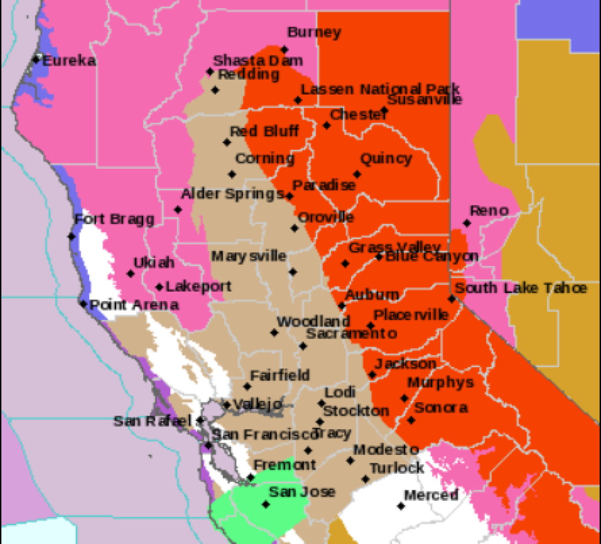
Blizzard warnings cover an area from Yosemite National Park from the Upper San Joaquin River to Rodgers Ridge in Kings Canyon National Park until 10 a.m. PST on Sunday.
For this region, the NWS forecasts snowfall of 6 to 8 feet for areas over 6,000 feet, with 2 to 4 feet of snow expected for those regions between 4,000 and 5,000 feet. Wind gusts could reach as high as 65 miles per hour on some ridgetops.
Mario Tama/GETTY
As a result, “travel will be dangerous to impossible” as “widespread blowing snow will reduce visibilities to near zero in whiteout conditions at times.” The powerful wind and heavy snowfall could also bring down trees and power lines.
People are advised to travel only in emergencies, and if they do so to have a winter survival kit in the vehicle. If stranded, the NWS urges you to remain with your vehicle.
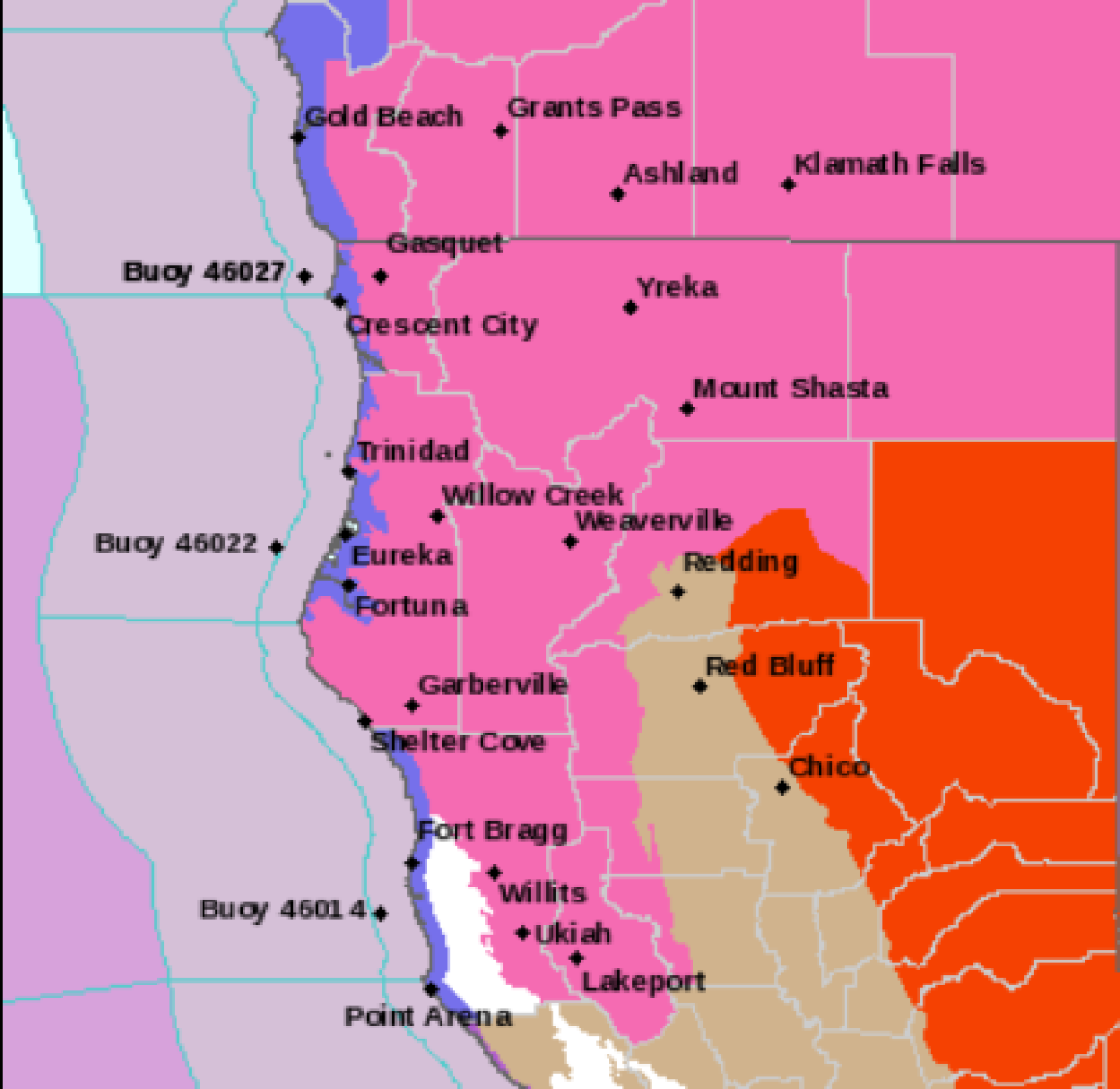
National Weather Service
Blizzard warnings are also in place for the northern Sierra Nevada mountain range, Mother Lode Country and parts of Lassen Volcanic National Park above 2,000 feet until 10 a.m. PST on Sunday.
In these areas. travel will be “extremely dangerous to impossible” and should be attempted only in case of emergency. Snowfall rates could reach 2 to 4 inches per hour, while there is a danger of extended power outages.
Areas above 5,000 feet should expect snow accumulations of 5 to 10 inches, which could top 12 feet on peaks. Wind gusts of 75 miles per hour or higher are also forecast.
National Weather Service
On X, formerly Twitter, storm chaser and weather expert Colin McCarthy speculated wind speeds could “approach the all-time California wind record of 199 mph along the Sierra Crest.”
Yosemite National Park closed on February 29, with visitors urged to “leave as soon as possible.” The website said the park will remain shut “at least through Sunday at noon (possibly later).”
On Friday, the NWS also issued warnings for Idaho, Montana, Nevada, Oregon, Utah, Washington and Wyoming, parts of which it said should expect snowfall and powerful winds.
As of 5:30 a.m. ET, around 43,500 customers were without power in California, according to the PowerOutage.US website, which tracks outages across the country.
On Friday, authorities in California closed around 100 miles of the I-80 in response to spin-outs, high winds, and low visibility. A tornado was also reported in Madera County, which damaged an elementary school, according to Andy Bollenbacher, a NWS meteorologist.
Extreme weather expert Jonathan Petramala shared footage of the I-80 gridlocked on X and said that “hundreds of cars” had been stranded with it. There was a race to see whether authorities “clear the interstate before cars get too buried.”
Six NWS blizzard warnings are also in place on Saturday for Nevada, covering regions including the Ruby Mountains, White Pine County, Lincoln County, the Greater Lake Tahoe Area and Mono County.
Uncommon Knowledge
Newsweek is committed to challenging conventional wisdom and finding connections in the search for common ground.
Newsweek is committed to challenging conventional wisdom and finding connections in the search for common ground.