


Tropical storm warnings are in force across southern California as Hurricane Hilary makes its way north towards Mexico’s Baja California peninsula, with American warships heading out to sea and soldiers from the Nevada National Guard being called up in preparation.
Hilary is forecast to hit southern California by Sunday night, though its strength is expected to have fallen to tropical storm level with wind speeds of around 50 miles per hour, amidst fears of widespread flooding.
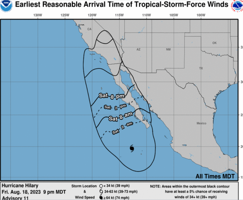
A map produced by the federal National Weather Service (NWS) projects Hilary will pass right by Baja California before making landfall just south of the U.S. border at 6 p.m. MDT on Sunday, after which it will continue its path north until it passes the Nevada state border at around 6 a.m. MDT on Monday.
ALFREDO ESTRELLA/AFP/GETTY
In an accompanying update published at 9 p.m. MDT on Friday, the NWS warns flooding could hit the southwestern parts of the country from Saturday.
It states: “Heavy rainfall associated with Hilary will begin well in advance of the center, from the Baja California Peninsula into the Southwestern United States. Preparations for the impacts of flooding from rainfall should be completed as soon as possible, as heavy rain will increase ahead of the center on Saturday.
“In the Southwestern United States, flash, urban, and arroyo [dry channel] flooding is expected, with dangerous and locally catastrophic impacts likely.”
National Hurricane Center
Hurricane strength winds, of at least 74 miles per hour, are expected along the west-central coast of the Baja California Peninsula over Saturday night.
The NWS update continued: “Tropical storm conditions are expected to begin on Sunday in portions of southern California where a Tropical Storm Warning is in effect.
“Large swells generated by Hilary will affect portions of the coast of southwestern Mexico, the Baja California peninsula, and southern California over the next few days. These swells are likely to cause life-threatening surf and rip current conditions.”
A separate NWS map gives a greater than 60 percent chance that the south-western tip of California will experience tropical storm force winds, though the probability decreases substantially as you head further north into the state. There is also a 5-10 percent chance that south-western parts of Arizona, and a slither of Nevada along the California border, could also face winds of this strength.

National Hurricane Center
On Friday night it was announced U.S. Navy vessels based around San Diego would head out to sea in a bid to dodge the storm.
Vice Admiral Michael Boyle, who commands the U.S. 3rd Fleet, commented: “In order to ensure the safety of our Sailors and ships, we are taking all necessary measures to mitigate potential damage to infrastructure and Third Fleet vessels caused by the storm.
“Safety remains our top priority, and putting all capable ships to sea makes it easier for us to manage the situation ashore.”
Nevada Governor Joe Lombardo announced he had activated 100 National Guard troops on Friday, in preparation for Hilary’s arrival.
Speaking to Newsweek on Thursday, Eric Boldt, a warning coordination meteorologist at the NWS station in Los Angeles, warned of “flash flooding” for some areas.
He said: “Rains could trigger flash flooding if the intensity is high enough, but otherwise most areas will be able to absorb several inches of rainfall.”