


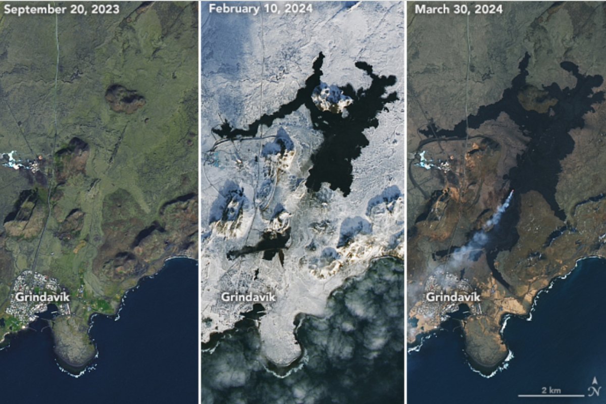
The increasing extent of land charred by the volcanic eruptions on Iceland’s Reykjanes peninsula can be seen in NASA images taken from space.
The volcano erupted for the fourth time on March 16, having erupted previously on December 18 last year, then again on January 14 and on February 8.
The most recent eruption is still ongoing, pouring lava out of a 2-mile-long fissure and scorching large areas of the nearby region coming close to the boundaries of the town of Grindavík.
NASA Earth Observatory image by Lauren Dauphin, using Landsat data from the U.S. Geological Survey / ICELANDIC DEPARTMENT OF CIVIL PROTECTION AND EMERGENCY MANAGEMENT/AFP via Getty Images
“Experts from the National Land Survey of Iceland have processed satellite data from 27 March showing that the lava field was then 5.99 km2 [2.31 square miles] and the volume of lava since the beginning of the eruption was 25.7 ± 1.9 million m3 [908 million cubic feet ± 67 million cubic feet]. The average extrusive rate of lava from the craters was estimated at 7.8 ± 0.7 m3/s [275 cubic feet/s ± 25 cubic feet/s], which is very comparable to the extrusion rate during the first phase of the Geldingadalir eruption in 2021,” the Icelandic Meteorological Office said in a statement on April 2.
NASA’s OLI (Operational Land Imager) on Landsat 8 captured an image on March 30 showing the lava streaming out of the two active craters, alongside a large swath of blackened land that has been burned and coated in cooled lava by the continuing eruptions over the past few months. Images taken on September 20 and February 10 show how the charred land has expanded over the course of the eruptions.
The eruption is currently stable, though it is anticipated to wane soon.
“The eruption at the Sundhnúkur crater row continues and two craters are now active. The third crater, which was much smaller than the other two, was extinguished at Easter. Volcanic tremor remains stable,” the IMO said in the statement. “Inflation in Svartsengi has not been detected in recent days, indicating that less magma accumulates in the magma reservoir beneath Svartsengi, and flows instead towards the craters where it erupts.”
The nearby Blue Lagoon was evacuated on March 16 when the current eruption began, as well as the nearby fishing town of Grindavík, which was damaged by lava flowing from some of the previous eruptions. Barriers constructed near the town successfully diverted much of the new lava away, though one road was covered by the molten rock.
These eruptions have not created a large cloud of ash like the one that caused major disruptions to flights after the 2010 eruptions of the Eyjafjallajökull volcano, instead releasing plumes of gases including water vapor, sulfur dioxide, and carbon dioxide. This most recent eruption released a sulfur dioxide plume that traveled to Ireland and the United Kingdom.
“The current eruptions around Grindavik are also quite different to the 2010 eruption of Eyjafjallajokull which created huge ash plumes that disrupted air travel for weeks. The Eyjafjallajokull eruption began under a glacier, allowing meltwater to interact with the lava as the eruption progressed,” Chris Firth, a volcano researcher at Macquarie University in Australia, told Newsweek.
“The meltwater was flash heated to steam, causing it to expand and create an ash rich, explosive eruption. In contrast, the current Grindavik eruption is away from glaciers, so the eruption primarily involves lava flows.”
NASA Earth Observatory images by Lauren Dauphin, using Landsat data from the U.S. Geological Survey.
This toxic gas is also being blown across Iceland, with high levels of it being detected in Höfn and Grindavík over the weekend, and forecast to be blown to the Reykjanes area, including Reykjanesbær, over the next few days.
“This concentration is considered very unhealthy, and people are likely to experience respiratory symptoms if exposed. It is important to stay indoors, close windows, and turn off air conditioning,” the IMO said.
The lava has also started numerous fires across the peninsula.
“[This] is an ongoing risk while the weather is dry,” the IMO said.
This eruption is unlike the previous three in that it has lasted several weeks, while the others only lasted a few days each. This may mean that the magma now has a shorter and faster route to the surface. It could also mean that the magma chamber is no longer accumulating magma underground, which could make this eruption the last one for a while.
Do you have a tip on a science story that Newsweek should be covering? Do you have a question about volcanoes? Let us know via [email protected].
Uncommon Knowledge
Newsweek is committed to challenging conventional wisdom and finding connections in the search for common ground.
Newsweek is committed to challenging conventional wisdom and finding connections in the search for common ground.