


Hurricane season is in full swing, as a third tropical storm has been named in the Atlantic Ocean over the past few days.
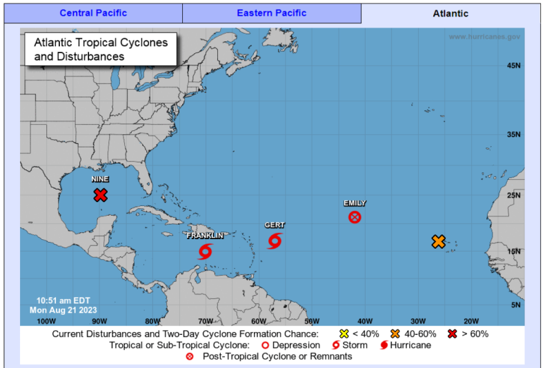
Tropical Storm Gert on Monday became the eighth named storm of the 2023 Atlantic hurricane season, as it formed east of the Leeward Islands. Two other tropical storms—Storm Emily and Storm Franklin—were named over the weekend.
The mounting bad weather in the Atlantic comes amid record-breaking rainfall along the Pacific coast due to Tropical Storm Hilary.
Handout/NOAA/Getty
According to the National Hurricane Center, Storm Gert is expected to be short-lived. Storm Emily too was short-lived, and has been downgraded to a “remnant low” one day after forming. A remnant low is the name give to a post-tropical cyclone that can no longer sustain the high wind speeds required to form a cyclone.
Storm Franklin, meanwhile, is expected to bring tropical storm conditions to the Dominican Republic and Haiti from Tuesday and heavy rainfall to Puerto Rico and Hispaniola, the National Hurricane Center has forecast. This rainfall may produce flash flooding and mudslides, with potentially life-threatening flash floods in Hispaniola on Tuesday into Wednesday.
Storms have been getting names since the early 1950s. They were introduced to avoid confusion between different weather systems. At first, storms in the United States were only given female names, but they began adding male names to the mix in the late 1970s.
The naming process is highly methodical. Six lists of names are used in rotation for each regional basin. These are maintained and updated by an international committee of the World Meteorological Organization.
Each list is organized alphabetically with alternating male and female names. The first storm of the year will start at the beginning of the alphabet—this year, the first named storm of the season was Storm Arlene, which formed in the Gulf of Mexico on June 2.
The only time these name lists are changed is when a storm is so deadly or destructive that the future use of the name would be insensitive. Examples include Hurricane Katrina in 2005 and Hurricane Sandy in 2012.
Tropical storms are formed when warm, moist air over the ocean rises upward, causing an area of lower air pressure beneath it. This allows air from higher air pressures to push into this low pressure system, causing this “new” air to become warm and rise too.
As this air cools down, it begins to condense into large, swirling clouds, which spin and grow, fed by water evaporating continuously from the ocean’s surface.
NOAA/National Hurricane Center
As the storm system begins to rotate faster and faster, an “eye” develops in the center of the storm. When the wind speed around this eye is sustained at over 39 miles per hour, the weather system is classified as a “tropical storm,” and qualifies for a name.
Only when wind speeds reach 74 miles per hour does a storm qualify as a tropical cyclone, or hurricane.
All eyes are now on a weather system brewing in the Gulf of Mexico, which is currently referred to as “potential tropical cyclone nine.” According to the National Hurricane Center, wind speeds in this weather system have reached 30 miles per hour and there is a 90 percent chance that it will develop into a full-blown tropical storm over the next 48 hours. Weather warning are already in place across South Texas.
Potential Tropical Cyclone #Nine Advisory 1: Tropical Storm Warning Issued For Portions of South Texas. Flooding Rains and Coastal Flooding Are Possible. https://t.co/tW4KeGdBFb
— National Hurricane Center (@NHC_Atlantic) August 21, 2023