


Just as the remnants of Tropical Storm Hilary make its way across Southern California, bringing heavy rains and flash flooding to the region, three more cyclones are moving westward in the Atlantic.
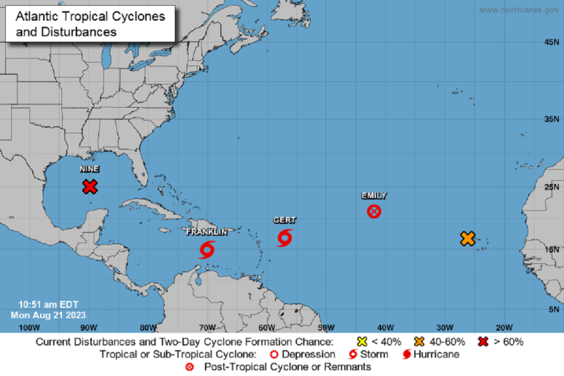
Tropical storms Franklin, Gert and Emily are all headed towards the Gulf of Mexico, though meteorologists are predicting that the closest, Franklin, will veer away from the continental United States after passing over the Dominican Republic and Puerto Rico.
However, the National Weather Service (NWS) said in its latest forecast on Monday that there was “more than the usual amount of uncertainty in the 3-5 day track prediction,” suggesting the storm could change its expected direction. Meanwhile, weather patterns within the Gulf of Mexico have the potential to form another tropical storm much closer to land.
On the opposite coast, the NWS issued a flash flood warning for parts of Southern California, including Los Angeles and Malibu, after Hilary, which had been a Category 4 hurricane at sea, made landfall on Sunday.
NOAA/Esri/HERE/Garmin
In its latest forecast, meteorologists for the agency wrote that in southwestern U.S. states, the “ongoing and potentially historic amount of rainfall” is expected to cause life-threatening or locally catastrophic flooding, including landslides and mudslides.
While Hilary is one of a handful of tropical storms to make landfall in California since records began, many more move in from the Atlantic into the Gulf of Mexico. In the Atlantic, hurricane season runs from the start of June to the end of November, though many of the storms tend to form through the latter part of August and September.
Storm Franklin is currently located to the south of Haiti in the Caribbean Sea, where it is moving westward. However, the National Hurricane Center (NHC) predicts it will turn northwards in the coming day due to its current “problematic” trajectory.
Meteorologists expect heavy rainfall from Franklin to fall across Puerto Rico and nearby islands, which “may produce areas of flash and urban flooding as well as river rises and mudslides.”
National Hurricane Center
Winds of up to 73 miles per hour are set to arrive on the Hispanola archipelago by 9 p.m. ET on Tuesday. Between two and four inches of precipitation are also anticipated to fall on Puerto Rico between Monday and Wednesday morning.
The NWS said that it expects the land masses Franklin encounters in the next few days to disrupt the storm, but this “will not be strong enough to prevent the system from eventually becoming a hurricane over the southwest Atlantic.”
The next tropical storm headed westward is Gert, currently located to the east of Puerto Rico. However, the NWS said that the tropical storm was quickly unravelling, and it predicts Gert to turn slightly northward before fizzling out at sea on Tuesday.
Further out is storm Emily, which began off the west African coast and now sits in the middle of the Atlantic Ocean. This too is predicted to dissipate in the coming few days, owing to an “increasingly belligerent” environment, and is set to become a post-tropical cyclone by Monday evening.
However, the NHC is keeping a close eye on a developing storm in the Gulf of Mexico, to the west of Cuba, where it said conditions appear favorable for development and the probability of a tropical storm forming there is high in the next two days. It added that storm watches and warnings may have to be issued for southern Texas as well.
Newsweek reached out to the National Hurricane Center via email for comment.