


Tornado watches are in place for a swath of the Midwest as meteorologists track thunderstorms across the region capable of producing twisters, maps show.
Watches are in effect across numerous counties in four states, with warnings being issued for individual locales as the threat of a twister appears imminent. The watches cover much of southern Illinois, a part of southwest Indiana, a portion of southeast Missouri and a small part of northwest Kentucky.
Warnings have already been issued for parts of northern Arkansas. A thunderstorm capable of producing tornadoes was located over Western Grove, Arkansas, moving east at 50 miles an hour shortly before 4 a.m. ET.
The National Weather Service (NWS) predicts that the threat of thunderstorms will move northeast over the coming day, with the highest chance of tornadoes developing over Ohio and northern Kentucky.
NWS
In its latest forecast, the meteorological agency said that a front extending from the mid-Atlantic into the Ohio and Mississippi valleys would continue to develop into Wednesday morning, bringing the threat of frequent lightning, high winds and hail.
It also warned of an increased threat of tornadoes over the Ohio, Tennessee and Mississippi valleys that could have a strength of between 2-5 on the Enhanced Fujita scale, representing wind gusts of between 111 and more than 200 miles an hour.
The NWS said there was a risk of hailstones of more than two inches in diameter over parts of the Ohio Valley.
In the early hours of Tuesday morning, a severe thunderstorm capable of producing tornadoes and ping pong ball sized hail was tracked near Willisville, in Perry County, southwest Illinois. The NWS said damage to trees and properties was likely, while mobile homes could be “damaged or destroyed.”
NWS
Another warning was issued for Jefferson County in south central Illinois a short while later, with a thunderstorm located nine miles to the north of Mount Vernon and moving east at 50 miles an hour.
Modeling suggests that the greatest threat of tornadoes is expected to shift northeastward in the coming day. After sparking alerts for eastern Oklahoma and Arkansas, the greatest risk through noon Wednesday will be over northern Kentucky, southeast Indiana and a large portion of Ohio.
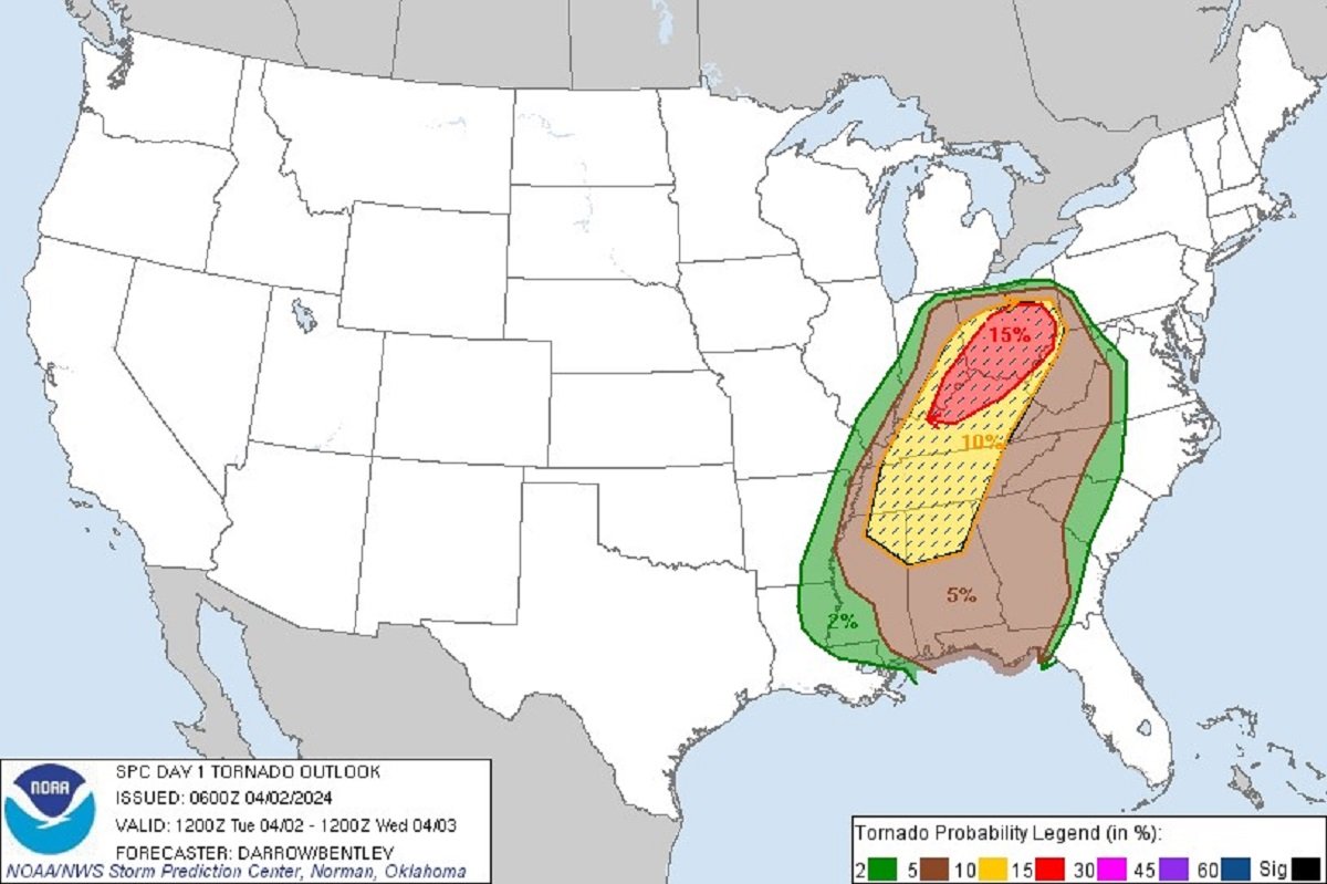
Maps produced by the NWS show that an area of nearly 39,000 square miles—including the cities of Columbus and Cincinnati in Ohio and Louisville, Kentucky—has a 15 percent probability of being within 25 miles of a tornado.
A further swath of nearly 96,000 square miles—including the cities of Nashville, Tennessee, and Birmingham and Huntsville in Alabama—has a 10 percent probability of being close to a twister.
An area of some 219,000 square miles reaching from the Florida panhandle to the northern counties of Ohio has a five percent chance of seeing a tornado.
On average, the U.S. sees around 1,200 tornadoes a year. Tornado season typically occurs in spring in the southeast.
In early December, at least 13 twisters powered across Tennessee, destroying properties and downing power lines. The storm also took the lives of at least two children and two adults.
Uncommon Knowledge
Newsweek is committed to challenging conventional wisdom and finding connections in the search for common ground.
Newsweek is committed to challenging conventional wisdom and finding connections in the search for common ground.