


Tropical storm Tammy, the 19th named storm of the hurricane season, may be about to strengthen to hurricane-force winds as it moves northwards.
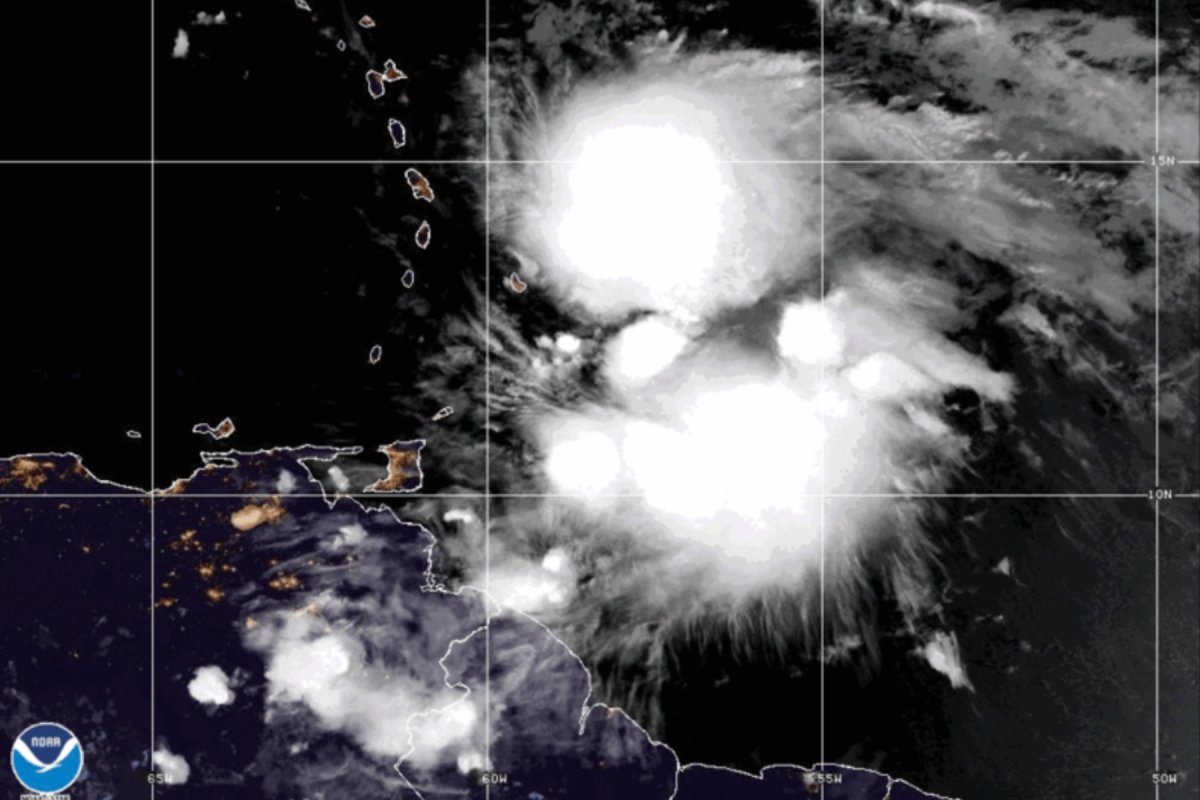
The storm, which is currently around 100 miles east of Barbados, is forecast to move gradually northwest towards the U.S. as it gets stronger, before a possible sudden veer northeast back into the Atlantic.
National Hurricane Center maps show the storm skirting past the Leeward Islands, with hurricane watches in effect in Guadeloupe, Antigua and Barbuda, Montserrat, St. Kitts and Nevis, and Anguilla, St. Maarten, and St. Martin and St. Barthelemy; tropical storm warnings in Dominica, Saba and St. Eustatius; and tropical storm watches in Barbados and Martinique.
National Hurricane Center NHC
Storm watches are issued around 48 hours before a hurricane or tropical storm is due to hit a certain area, while storm warnings are issued 36 hours beforehand.
“Tammy is moving toward the west-northwest near 10 mph (17 km/h). A gradual turn to the northwest with a decrease in forward speed is forecast later today, and this motion should continue through Saturday,” a National Hurricane Center public advisory said on Friday. “A more northward motion is forecast to begin Saturday night or Sunday. On the forecast track, the center of Tammy will move near or over the Leeward Islands later today through Saturday, and then move north of the Leeward Islands Saturday night and Sunday.”
The storm’s maximum wind speeds are around 60 miles per hour, with more intense gusts, and it is expected to strengthen possibly to hurricane strength by the weekend.
“Gradual strengthening is expected to begin later today and continue into this weekend. Tammy is forecast to be at or near hurricane intensity when it moves near the Leeward Islands tonight and Saturday,” the advisory said.
Hurricanes are defined as storms that have wind speeds of 74 mph or over, with anything below that being classified as a tropical storm or a tropical depression. Category 1 hurricanes have wind speeds between 74 and 95 mph, Category 2 hurricanes between 96 and 110 mph, Category 3 between 111 and 129 mph, Category 4 between 130 mph and 156 mph, and Category 5 hurricanes have wind speeds of 157 mph and over. Major hurricanes are categories 3, 4 and 5.
“Tropical storms develop from a cluster of clouds in the tropics with a cyclonic/rotational (rotate counterclockwise in the northern hemisphere, and clockwise in the southern hemisphere) wind pattern,” Haiyan Jiang, a professor of Earth and environment at Florida International University, told Newsweek.
Storms may strengthen as they move over the ocean, upgrading from tropical storm to hurricane, or increasing between hurricane categories.
“There are many environmental factors that control how a storm intensifies or weakens. Among them, the most important ones are warm sea surface temperatures and ocean heat content, low vertical wind shear, and high atmospheric moisture,” Jiang said.
CIRA/NOAA/NEDIS/STAR
Tammy is expected to lash the Leeward Islands with rain as it passes, pouring a predicted 4 to 8 inches of rain, and up to 12 inches at most. The Northern Windward Islands are forecast to receive 2 to 4 inches, while the British and U.S. Virgin Islands into eastern Puerto Rico may see between 1 and 2 inches. This deluge of rain is feared to create flash flooding in urban areas, and possibly trigger landslides in some areas.
In the future, with the encroaching effects of climate change, the impacts of tropical storms and hurricanes may cause increased destruction in urban areas.
“The rates at which hurricanes strengthen, and the frequency with which they transition from relatively weak storms into major hurricanes has significantly increased in just the last 50 years, over the same time when we see substantial increases to ocean surface temperatures due to human-caused warming. Without major changes in our behavior, and a rapid transition away from fossil fuels, this is a trend that will continue to get more extreme,” Andra Garner, assistant professor at Rowan University in New Jersey, previously told Newsweek.
“We are already seeing overall increases to the fastest rates at which Atlantic hurricanes intensify—which means that we are likely already seeing an increased risk of hazards for our coastal communities. This means that it will be especially important for our coastal communities to work towards enhanced coastal resiliency measures and emergency action plans that may be able to adapt to hurricanes that strengthen more quickly,” she said.
Do you have a tip on a science story that Newsweek should be covering? Do you have a question about tropical storm Tammy? Let us know via [email protected].