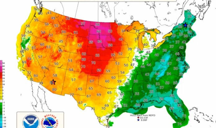
Americans should brace for a truly mixed bag of weather this week as a winter heat wave and major storm are set to affect swaths of the country.
New weather maps from the National Weather Service (NWS) show balmy temperatures from Wednesday and into the weekend, followed by what could be a dramatic storm hitting eastern areas, with thunderstorms and heavy rain on the cards for an estimated 180 million people.
Posting the latest map on X (formerly Twitter), the NWS wrote: “A surge of warmth bringing temperatures 20-30 or more above average to the northern tier today will swing eastward this weekend accompanied by strong winds and a developing storm for the eastern half of the country this weekend.”
Warm air looks set to peak in the central states, with the NWS reporting temperatures in the 60s across South Dakota and 70s across Kansas. Both are around 20 to 30 degrees above average when compared with the usual early-December climate in these areas, according to the NWS.
National Weather Service
Newsweek has contacted the NWS for comment via email.
While some may be able to bask in unseasonable warmth for now, as the weekend approaches those same states will be hit by a cold front extending from northern Texas up to the northern tier states. Snow is likely to form in areas in and around the Rocky Mountains, Salt Lake City and Denver and move eastward.
Weather Channel meteorologist Domenica Davis said: “We have a late-week storm that is going to bring severe back into the picture. An area down to the south is where we could see those severe storms develop. Not only do we have that element but the winter weather aspect of this storm too.”
She went on: “As we go through the weekend, there is the snow through the Rockies, moving to the east, and that rain-snow line starts to set up through the Central Plains and into parts of the Midwest, and that could develop some tricky travel throughout the weekend.”
Accuweather forecasters have warned that “dangerous thunderstorms will threaten millions.” Brandon Buckingham, an AccuWeather Meteorologist, said: “As cold air rushes in on the back side of the storm and meets up with the mild and humid air, the clashing air masses will spark severe thunderstorms across the south-central U.S. Friday before extending across the South on Saturday.”
Northeastern and Southern states look to be the worst affected. Heavy rain and thunderstorms are expected on Sunday night all the way from Jacksonville, Florida, to Boston.
A surge of warmth bringing temperatures 20-30 or more above average to the Northerntier today will swing eastward this weekend accompanied by strong winds and a developing storm for the eastern half of the country this weekend.https://t.co/VyWINDk3xP pic.twitter.com/9joo5QUsek
— National Weather Service (@NWS) December 6, 2023
“As the storm progresses northeastward, it will gain strength and pull moisture from the Gulf of Mexico later Saturday, then from the Atlantic Ocean by Sunday,” Alex Sosnowski, an AccuWeather senior meteorologist, has forecast.
He continued: “The surge in moisture will lead to more fuel for thunderstorms and rain on the eastern half of the Mississippi Valley to the Appalachians and Atlantic coast, while the strengthening storm and trailing cold front will generate much stronger winds from the Appalachians to the Atlantic coast during the latter part of the weekend.”
Uncommon Knowledge
Newsweek is committed to challenging conventional wisdom and finding connections in the search for common ground.
Newsweek is committed to challenging conventional wisdom and finding connections in the search for common ground.


