


A storm system in the Atlantic has been upgraded and called Tropical Storm Philippe, becoming the 16th named storm of the hurricane season, as it inches toward the U.S.
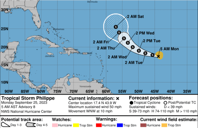
Philippe was named on Saturday night as it increased in strength on its journey westward across the central Atlantic Ocean, as shown by NOAA models. As of 5 a.m. AST on Monday, it had maximum sustained wind speeds of 50 mph.
“At 500 AM AST (0900 UTC), the center of Tropical Storm Philippe was located near latitude 17.4 North, longitude 43.9 West. Philippe is moving toward the west-northwest near 10 mph (17 km/h),” the National Hurricane Center said in a Monday morning advisory. “This general motion is expected for the next day or two, with a gradual turn to the northwest by mid-week. Maximum sustained winds remain near 50 mph (85 km/h) with higher gusts. Little change in strength is forecast during the next few days. Tropical-storm-force winds extend outward up to 115 miles from the center.”
CIRA/NOAA/NEDIS/STAR
No coastal watches or warnings are in effect yet, as the storm is still a long way off the U.S. east coast.
Philippe comes days after Storm Ophelia, which caused widespread flooding as it made landfall in North Carolina, and only around a week after Hurricane Lee slammed into New England. Storms are named alphabetically in order of occurrence every year: 2023’s storms were named Arlene, Bret, Cindy, Don, Emily, Franklin, Gert, Harold, Idalia, Jose, Katia, Lee, Margot, Nigel, Ophelia, Philippe, Rina, Sean, Tammy, Vince, and Whitney.
Tropical storms are storms that form due to areas of lower pressure over warm tropical ocean waters. This lower pressure causes warm and moist air to rapidly rise, and begin to spin because of the Earth’s rotation. This may progress into a tropical depression, and then into a tropical storm, depending on sea temperatures and humidity.
Once wind speeds reach 74 mph, a storm is reclassified as a hurricane. Category 1 hurricanes are between 74 and 95 mph, Category 2 between 96 and 110mph, Category 3 between 111 and 129mph, Category 4 between 130 mph and 156mph, while Category 5 hurricanes are 157mph and over.
“There are a few main environmental factors that influence how powerful a storm can get. The most popular factor is the temperature of the ocean water beneath the storm,” Sam Lillo, a forecast engineer at DTN Weather, previously told Newsweek.
“Wind blowing over water causes an exchange of moisture into the atmosphere, encouraging the growth of deep clouds and heating that intensifies low pressure at the surface, ultimately strengthening the winds and furthering this feedback loop. The warmer the water is, the more moisture and heat that can fuel the storm, and the stronger this feedback process becomes.”
The NHC currently forecasts Philippe is moving northwest toward the U.S. East Coast, but this may change in the coming days as several other environmental factors come into play.
“The track of the storm is determined by the environmental winds which steer the vortex. What can introduce uncertainty in the track forecast is when these steering winds vary across a short distance,” Lillo said.
“So for example, if the storm drifts just a little north or south, it could dramatically change what steering winds are influencing it. Also sometimes when a new storm forms and is weak and not quite consolidated yet, the center of the storm can wobble around a lot, again changing what the environmental winds are that subsequently steers it forward.”
NOAA/NHC
If the storm does make landfall, it may cause flooding and property damage, as many of the storms this season have done. Climate change is feared to be making these storms more powerful, worsening their effects on people in their path, experts say.
“Climate change is clearly increasing the upper limit on hurricane strength and rain rate due to both the increasing temperature of the ocean, which provides the energy for the storms, and the increasing temperature of the atmosphere, which allows for more intense rain,” Mathew Barlow, a professor of environmental earth and atmospheric sciences at the University of Massachusetts-Lowell, previously told Newsweek.
“Additionally, the warming increases average sea levels and so makes storm surge worse. Other aspects are less clear, including possible increases or decreases in the overall number of hurricanes in a year, although we do expect the proportion of hurricanes that are major storms to increase.”
Do you have a tip on a science story that Newsweek should be covering? Do you have a question about hurricanes? Let us know via [email protected].